Check out the selenographic landmarks of the mission on Google Moon (Luna's equivalent of Google Maps), and the great Discovery Channel documentary miniseries "When We Left Earth: The NASA Missions" includes a particularly neat (if brief) look at the mission.
The mission occured 27 years ago this week (December 7th-19th, 1972), and is the last time a man walked on the moon (until, of course, approximately 2020, when most likely a taikonaut will become the 13th man on the moon).
"As I take man's last step from the surface, back home for some time to come — but we believe not too long into the future — I'd like to just [say] what I believe history will record — that America's challenge of today has forged man's destiny of tomorrow. And, as we leave the Moon at Taurus-Littrow, we leave as we came and, God willing, as we shall return, with peace and hope for all mankind. Godspeed the crew of Apollo 17." – Eugene A. Cernan, Apollo 17 Commander. Last man to walk on the moon, December 14, 1972.
The Chandrayaan-1 lunar orbiter (which just Saturday reached lunar orbit) has 11 scientific instruments onboard to complete an array of measurements: five Indian instruments, and six from other nations and organizations (including the ESA and NASA). Japan and China launched similar missions last year, but not with foreign instruments onboard.
This chart below, from the ISRO, shows what types of 'coverage' the payloads as a unit have:
As I cover each of the eleven payloads in individual posts over the next few weeks, I'm going to alternate between the Indian and foreign payloads.
An Indian instrument, the first payload being featured here was also the first one to be tested.
It's mostly as it sounds: a high-resolution camera that can take black and white photographs of the lunar surface (with a 5m spatial resolution--"the ability to distinguish between two closely spaced objects on an image"--in 20km swaths[PDF] ), with the intent to map the entire topography of the moon (including the dark side and the poles) at that 5m resolution; creating the most high-resolution, detailed map of the lunar surface to date. Such maps exist of Mars, but not of the Moon.
NASA's Lunar Reconaissance Orbiter (LRO) mission set for next year will have similar, if more powerful, camera and mapping systems. These kinds of maps will clearly be useful for the planning stages of the eventual lunar colonies and for other efforts.
The power of the TMC could well be enough to finally settle one thing for NASA ahead of time, though: it could photograph the Apollo and other NASA craft on the Moon's surface, hopefully putting all those conspiracy theories to rest. :)
Here's a picture from the ISRO of the TMC itself:
And, last but not least, one of the test images the camera took of Earth (high resolution here): For every technical detail you ever wanted to know about the TMC, see this PDF.
Check back within the next couple of days for the next feature, on one of the Chandrayaan-1's foreign payloads, as well as for any other updates on the moon mission's progress that may come along :)
Check out the press release for the official take, as well as theseneatarticles. This was a test of the TMC, which is one of five Indian payloads on the Chandrayaan-1 (the other six being international, including two through NASA).
I'm going to be doing a series of individual spotlights on all eleven payloads as the Chandrayaan-1 makes its way out of its current Earth orbit and towards the Moon, so keep an eye here for the first installment of that very soon :)
"Astrobotic will robotically explore the Moon’s high-interest areas on a commercial basis, collecting information required to design future outposts and to answer scientific questions about the Moon and Earth." -David Gump, President of Astrobotic, from their announcement
As part of the announcement, Astrobotic released a White Paper (a 'white paper' being an a report or guide that addresses problems and how to solve them, typically seen in business and politics) detailing their program and goals.
In addition to their initial effort for the $20 million Lunar X Prize, TranquilityTrek (which, as David Gump told Space.com for their article today, was "very clear" that it was "going to cost more to win the prize than the prize itself"), Astrobotic will follow with five more missions:
Rovers and landers are pretty commonplace ideas, but the 'dozer' was a new one to me. With some digging (excuse the pun), I found an example: NASA's Lunar Chariot prototype, which could build roads, dig trenches, or even mine minerals. There's even some video of it in action, kicking ass and taking names on Earth:
The White Paper has oodles of details on their exact mission plans, particularly the diagram on page 3.
With the X Prize TranquilityTrek slated for Q2 2010, they've got their South pole scout (headed for the rim of Shackleton Crater, long considered a prime location for a moon colony) shooting for Q3 2011, with two more missions (a North Pole scout and a 'Moon Quake 1" seismic and weather collection mission at Shackleton) set for 2012 and an Ice Surveyor mission going deep into Shackleton itself, followed by the Lunar Dozer mission also at Shackleton Rim, both being conducted in 2013.
So, for Astrobotic alone, that's 6 total lunar missions in the next four years. Exciting times. And this, of course (and as the White Paper notes), is just the initial slate. Most or all of the rovers will include HD video broadcasting, it sounds like, so we'll all have a front row seat, to boot.
The general goal of the missions is to build a data library to facilitate other organizations' (e.g., NASA; Barack Obama, in his space plan, talked of "amplifying NASA's reach" with the private space sector) and companies' missions with information for sale, such as detailed terrain maps, allowing future colonial efforts to simply buy the information from Astrobotic at a lower cost that it would take for the efforts to collect the data themselves.
Check out that 4-page White Paper and Astrobotic's site for the full skinny on their efforts, and keep an eye here for frequent updates and analysis as they (and other similar companies, such as fellow Google Lunar X Prize competitor Odyssey Moon, Ltd.) progress rapidly towards their mission slate :)
An unmanned lunar explorer (a la Japan's Kaguya), the Chandrayaan-1 (which is "moon craft" in Sanskrit) is set to map lunar topography in 3D, creating (as the ISRO puts it) a "3D atlas" and notably, chemical mapping of the lunar surface.
While I haven't found any specific references to helium-3 in any Indian or other documentation of the Chandrayaan project, that prominent "chemical mapping" goal suggests that, like Russia, China, NASA, and others, India is seriously interested in the resource potential of the Moon.
This story got some big media play in the form of a huge front-page Drudge Report splash, with a huge picture of the Moon in the place usually reserved for the likes of Obama and McCain. Here's that spectacular image (which ran with an "INDIA TO THE MOON!" headline):
I'm a little surprised at the high-profile coverage, as this Indian mission isn't a whole lot different than JAXA's, which didn't appear to get quite the same sort of media push. I think this speaks to the sort of excitement the Base Race can generate, especially as the significant 2010-2020 decade pulls closer (and as things domestically get more and more grim in the meantime).
I discovered the other day, and installed last night, a stellar program for anyone interested in off-Earth colonization, selenology/selenography (and their Martian equivalent, areology), and coolness in general: NASA's World Wind. (Note: it's unfortunately Windows-only at the moment...*Nick's bad childhood memories of limited Mac software recur*...).
Very similar to Google Earth, but with that NASA touch and focus, the program lets you look at Earth, the Moon, Mars, Jupiter, Venus, and the Sloan Digital Sky Survey (SDSS) in that familiar Google Earth-esque interactive globe fashion. You can spin Mars around like an intergalactic DJ or, as is most relevant here, peer down at all kinds of features our beloved Luna, labeled and all.
The Lunar globe as it appears in the program.
A look at Mare Tranquillitatis and its color-coded features; yellow being craters, etc.
I'll admit the Lunar globe is actually the iffy-est of the globes, despite the abundance of labeled features; it's a little hole-ridden, especially on the Dark Side (understandably), and also rather noticably around the poles (and thus including some of the most important colonial features, like Shackleton and Malapert).
Still, it's an awesome and easy-to-use program (screenshots are a breeze, as you see above), and it's got its own giant Wiki to support it (the official site seems severely out-of-date beyond the download, and I believe the Wiki is why). The Mars globe is a blast, and all in all it's a fascinating adventure of a program you could spend a lot of time enveloped in.
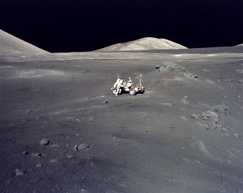 That is a NASA file image of astronaut Harrison "Jack" Schmitt (now an active supporter of helium-3 mining on the Moon) in Mare Serenitatis alongside he and Eugene Cernan's rover during the Apollo 17 mission, in which astronauts spent by far the most amount of time exploring the surface, roving for 21 miles instead of the hundreds of yards previous astronauts had been limited to.
 As I cover each of the eleven payloads in individual posts over the next few weeks, I'm going to alternate between the Indian and foreign payloads.


 Posts
Posts


